
Recent Publications
- Glacier shrinkage and slope processes create habitat at high elevation and microrefugia across treeline for alpine plants during warm stages
- The Late Holocene tephra record of the central Mediterranean Sea: Mappingoccurrences andnewpotential isochrons for the 4.4–2.0 ka time interval
- Evidence for a link between the Atlantic Multidecadal Oscillation and annual asthma mortality rates in the US
- Climate variability of the last ~2700 years in the Southern Adriatic Sea: Coccolithophore evidences
User login
You are here
Changes in snow resources in mountain areas
Surface temperature increase has important effects in mountain regions, where snow is a dominant climatic feature. The shift of the 0 degree isotherm to higher altitudes results in a decrease in the solid-to-total precipitation ratio in low- and mid-altitude mountain areas. In addition, higher temperatures favor snow melt, and consequently a reduction of the snow pack depth and of the snow cover extension. The newly snow-free soil absorbs a larger fraction of the incoming solar radiation, so it becomes warmer and it enhances the melting of the remaining snowpack. This mechanism generate a positive feedback which tends to accelerate the melting of the remaining snow mass.
A decrease in snowfall precipitation and an earlier and accelerated snow melt are expected to have implications on river discharge, in particular on the timing of the seasonal runoff, likely characterized in the future by earlier spring or even winter discharge and reduced flows in summer and autumn. Downstream regions will probably experience changes both in the amount and in the timing of water availability. In mountain areas, changes in the seasonality and amount of winter snow cover and spring snow melt are having significant impacts on mountain ecosystems, including high-altitude vegetation and the population dynamics of animal species that depend on snow resources such as ibex. For these reasons we need reliable estimates of current snow resources available in the Alpine range and reliable future projections of the expected changes in snow cover. These information are essential to develop adaptation and management strategies, in order to minimize the negative impacts of these changes on the society and the ecosystems.
Operational surface snowpack monitoring relies on networks of meteorological stations which measure the snow depth. Additional non-operational campaigns are carried out to measure the snow mass and the snow water equivalent (SWE). In both cases, observations are made at point scale, so they are representative of the local conditions of the snowpack. Currently the density of surface stations measuring snow is insufficient to develop a gridded dataset that reliably represents the spatial distribution of the snow mass. Additional information on snow characteristics can be derived from remote sensing observations, reanalyses and model simulations. Their advantage is a global, or regional, spatially continuous coverage. The disadvantages are a higher uncertainty associated to the snow estimates and, often, a coarse spatial resolution (~10-100 km), which does not allow to resolve fine scale spatial variability of snowpack.
In this project we aim to collect and evaluate the currently available snow water equivalent datasets providing data for the Alpine region. We will explore satellite products (Global Monthly EASE-Grid Snow Water Equivalent Climatology, AMSR-E/Aqua Monthly L3 Global Snow Water Equivalent ), reanalyses (Climate Forecast System Reanalysis-CFSR, Modern Era-Retrospective analysis for Research and Applications-MERRA, ERA-Interim/Land e 20th Century Reanalysis v2-20CR) and the climate simulations from (i) CORDEX regional climate models, driven by ERA-Interim reanalysis, (ii) CORDEX regional climate models driven by CMIP5 global climate models, (iii) CMIP5 global climate models. We consider this large ensemble of dataset from difference sources - remote sensing and reanalysis - to evaluate the degree of similarity among the different climatologies (Figure 1) e to estimate the uncertainty associated to snow data. These datasets will be taken as the “reference” to evaluate regional and global climate models, and to test their ability to reproduce the snow climatology during the historical period. After this inter-comparison effort, we will evaluate future projections in different climate change scenarios, with the objective to quantify the expected changes with respect to the current conditions and the uncertainty associated to these changes.
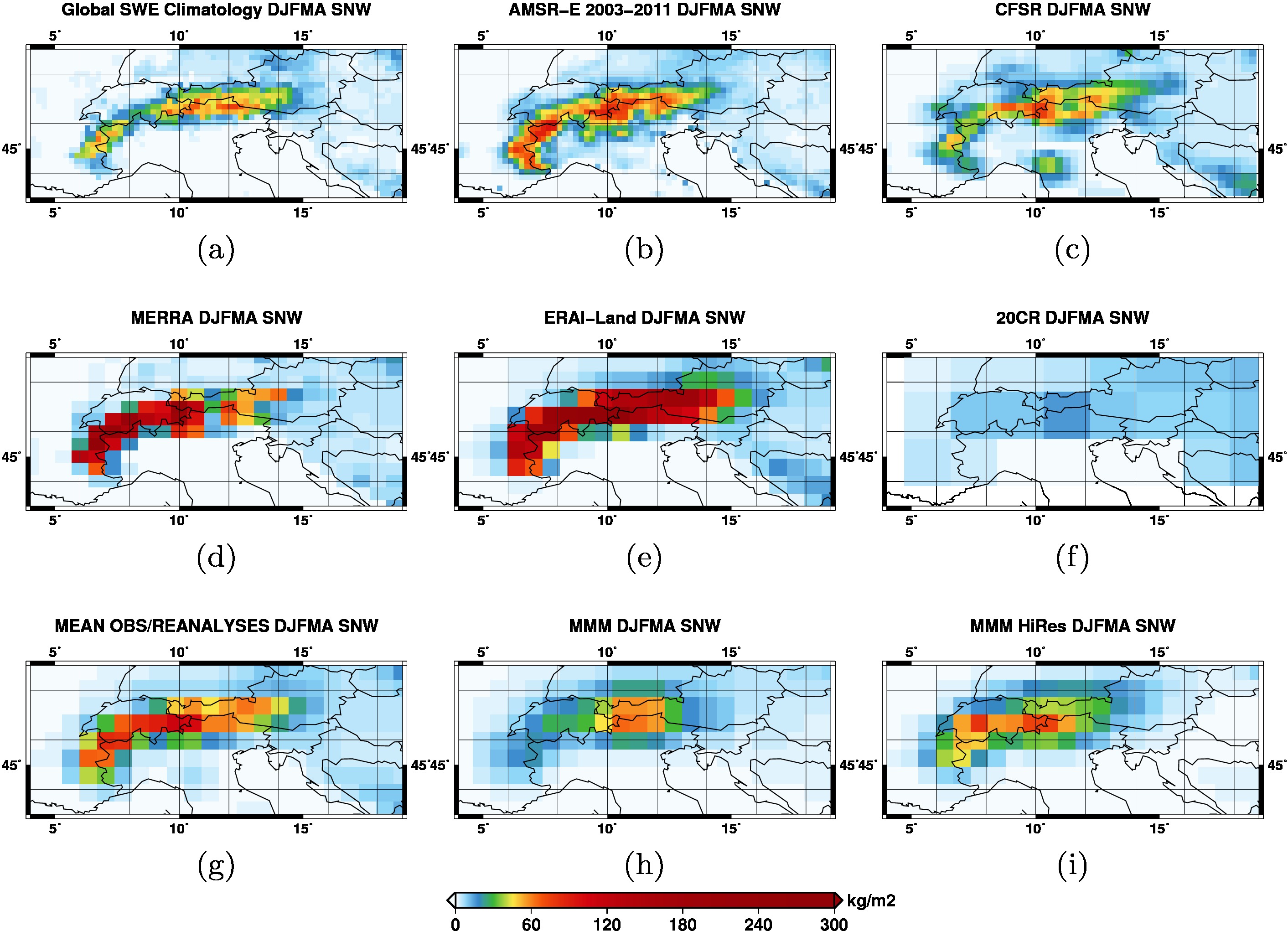
Figure 1. Spatial distribution of the DJFMA snow water equivalent (multiannual mean 1980-2005), derived from (a) Global Monthly EASE-Grid Snow Water Equivalent Climatology, (b) the AMSR-E/Aqua L3 Global Snow Water Equivalent EASE-Grids Version 2, (c) CFSR reanalysis, (d) MERRA reanalysis, (e) ERA-Interim/Land reanalysis, (f) 20CRv2 reanalyses. (g) Average of the reference datasets (MRM), (h) average of the snow water equivalent climatologies of CMIP5 models, (i) average considering only CMIP5 models with spatial resolution finer than 1.25°lon.
![]()
![]()
![]()
![]()
![]()
![]()
![]()
![]()
![]()
![]()
![]()
![]()
![]()
![]()
![]()
![]()
![]()
![]()
![]()
![]()
![]()
![]()
![]()
![]()
![]()
![]()
![]()
![]()

